HIGH FALLS COUNTY PARK
“High Falls is located just minutes from Seneca and ten miles from Clemson, South Carolina and Clemson University.”
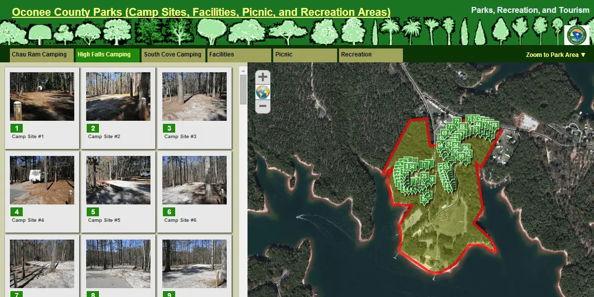
High Falls Park is a 46 acre park nestled in the foothills of the Blue Ridge Mountains and located on the shores of beautiful Lake Keowee. There are 91 campsites with 10 being waterfront. All have electrical hookup (20 &30 amp), water service, and bathhouses are located within the campgrounds with the dump station located outside the park entrance. The Park offers three rental buildings/shelters for reunions, birthday parties, award ceremonies, and picnics. Other day use facilities include picnic tables with charcoal grills, swimming area, restroom, miniature golf, one tennis and basketball court, volleyball, two boat ramps, fishing pier, and a playground. Lake Keowee is over 18,000 acres and provides a pristine, blue reservoir popular for water sports and fishing.
National Geographic released a Special Publication in November - 2012 titled "50 of the World's Last Great Places - Destinations of a Lifetime". Our remarkable Jocassee Gorges is one of those places.
The Mountain Lakes region offers an abundance of nearby attractions including the Sumter National Forest, Wild & Scenic Chattooga River, world class waterfalls, Stumphouse Tunnel, Upstate Heritage Quilt Trail, a thriving arts community, Clemson University and re-vitalized downtown atmospheres full of shopping and dining.
PARK INFORMATION
- Address: 671 High Falls Rd, Seneca, SC 29672
- Phone: 864-882-8234
- Park Hours: Gate Closed 10pm-7am.
- Quiet hours observed during gate closure.
- Park Rules
- Park Fees
DETAILS:
- Number of Sites: 91
- Shelters: 2
- Recreational Buildings: 1
- Boat Ramps: 2
- Attractions: Miniature golf, Horseshoes, Softball Field, Volleyball, Basketball Court, Playground
- Season: Day Use area/lake access open year round. Camping closed for the Winter mid-November through February. Contact Park for specific dates.
- Check Out Time: 12:00pm
- Pets Allowed
- Dump Station
- Tent Sites Available
- RV Sites
- Shower Facilities
- Electric and Water Hookups
PARK DIRECTIONS & TRAVEL MAP
From Seneca: Hwy 130 North for 10 miles. Hwy 130 merges with Hwy 183 at Duke Energy. Stay straight on Hwy 183 for two miles past Keowee Key. High Falls road is on the left and leads into the park.
From Cherokee Foothills Scenic Byway(Hwy 11): Take Hwy 183 South for approximately 6 miles. High Falls Road is on the right and leads into the park.
From Interstate 85: Take South Carolina exit 1(Hwy 11) towards Walhalla. Take Hwy 183 South for approximately 6 miles. High Falls Road is on the right and leads into the park.
INTERACTIVE PARK MAP